


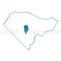
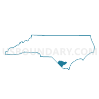
Voting District P11, Columbus County, North Carolina
About
Outline

Summary
| Unique Area Identifier | 639733 |
| Name | Voting District P11 |
| County | Columbus County |
| State | North Carolina |
| Area (square miles) | 23.04 |
| Land Area (square miles) | 23.01 |
| Water Area (square miles) | 0.03 |
| % of Land Area | 99.86 |
| % of Water Area | 0.14 |
| Latitude of the Internal Point | 34.23983460 |
| Longtitude of the Internal Point | -78.68810400 |
Maps

Graphs
Select a template below for downloading or customizing gragh for Voting District P11, Columbus County, North Carolina


Neighbors
Neighoring Voting District (by Name) Neighboring Voting District on the Map
- Voting District P01, Columbus County, NC
- Voting District P10, Columbus County, NC
- Voting District P13, Columbus County, NC
- Voting District P22, Columbus County, NC
- Voting District P25, Columbus County, NC
Top 10 Neighboring County Subdivision (by Population) Neighboring County Subdivision on the Map
- Whiteville township, Columbus County, NC (11,593)
- Williams township, Columbus County, NC (4,578)
- Lees township, Columbus County, NC (3,835)
- Bogue township, Columbus County, NC (3,058)
Top 10 Neighboring Place (by Population) Neighboring Place on the Map
Top 10 Neighboring Unified School District (by Population) Neighboring Unified School District on the Map
Top 10 Neighboring State Legislative District Lower Chamber (by Population) Neighboring State Legislative District Lower Chamber on the Map
Top 10 Neighboring State Legislative District Upper Chamber (by Population) Neighboring State Legislative District Upper Chamber on the Map
Top 10 Neighboring 111th Congressional District (by Population) Neighboring 111th Congressional District on the Map
Top 10 Neighboring Census Tract (by Population) Neighboring Census Tract on the Map
- Census Tract 9310, Columbus County, NC (5,687)
- Census Tract 9313, Columbus County, NC (5,653)
- Census Tract 9304, Columbus County, NC (4,062)
- Census Tract 9311, Columbus County, NC (3,752)